 Catalogue PIGMA
/Physical Environment/Bathymetry/Digital Terrain Model
Type of resources
Available actions
Topics
Keywords
Contact for the resource
Provided by
Years
Formats
Representation types
Update frequencies
status
Scale
Resolution
-
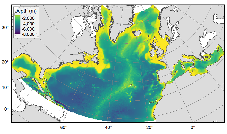
Distribution of three bathymetric terrain variables (depth, slope and Bathymetric Position Index) on the North Atlantic (18°N to 76°N and 36°E to 98°W). This dataset originated from three source layers (3km * 3km resolution) computed within the work package 3 of EU ATLAS project, and based on the EMODnet Digital Bathymetry portal and the General Bathymetric Chart of the Oceans (GEBCO). From these source layers, the mean depth (m), slope (degree) and BPI (no unit) were calculated for each 25km * 25km gridsquare. This dataset was built to feed a basin-wide spatial conservation planning exercise, targeting the deep sea of the North Atlantic. The goal of this approach was to identify conservation priority areas for Vulnerable Marine Ecosystems (VMEs) and deep fish species, based on the distribution of species and habitats, human activities and current spatial management.
-
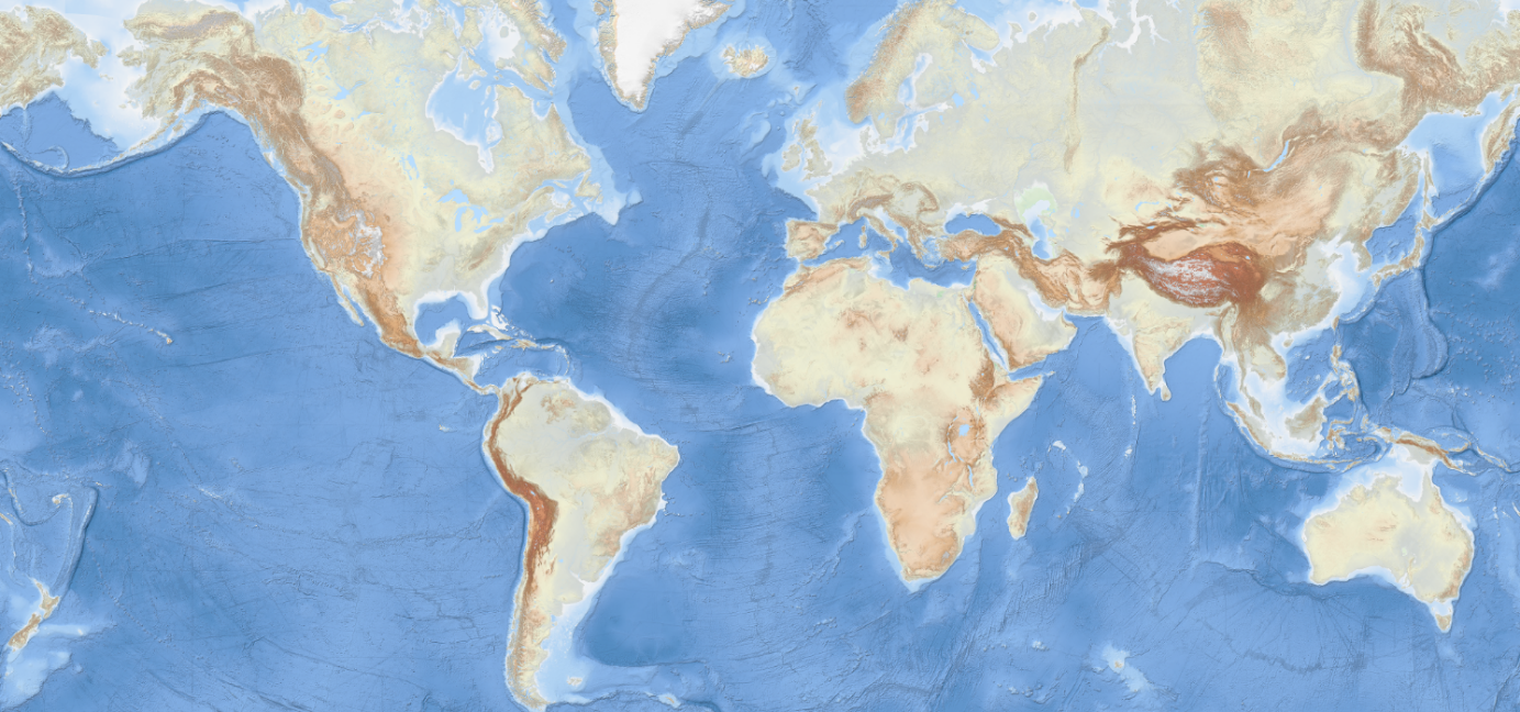
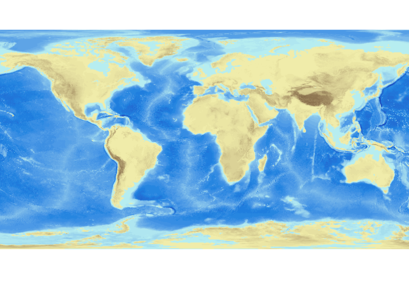
The GEBCO_2019 Grid is a global continuous terrain model for ocean and land with a spatial resolution of 15 arc seconds. The grid uses as a base Version 1 of the SRTM15_plus data set (Sandwell et al). This data set is a fusion of land topography with measured and estimated seafloor topography. It is largely based on version 11 of SRTM30_plus (5). Included on top of this base grid are gridded bathymetric data sets developed by the four Regional Centers of The Nippon Foundation-GEBCO Seabed 2030 Project, and from a number of international and national data repositories and regional mapping initiatives. The GEBCO_2019 Grid represents all data within the 2019 compilation. The compilation of the GEBCO_2019 Grid was carried out at the Seabed 2030 Global Center, hosted at the National Oceanography Centre, UK, with the aim of producing a seamless global terrain model. The majority of the compilation was done using the remove-restore procedure (Smith and Sandwell, 1997; Becker, Sandwell and Smith, 2009 and Hell and Jakobsson, 2011). This is a two stage process of computing the difference between the new data and the base grid and then gridding the difference and adding the difference back to the existing base grid. The aim is to achieve a smooth transition between the new and base data sets with the minimum of perturbation of the existing base data set. The data sets supplied in the form of complete grids (primarily areas north of 60N and south of 50S) were included using feather blending techniques from GlobalMapper software. The GEBCO_2019 Grid has been developed through the Nippon Foundation-GEBCO Seabed 2030 Project. This is a collaborative project between the Nippon Foundation of Japan and the General Bathymetric Chart of the Oceans (GEBCO). It aims to bring together all available bathymetric data to produce the definitive map of the world ocean floor by 2030 and make it available to all. Funded by the Nippon Foundation, the four Seabed 2030 Regional Centers include the Southern Ocean - hosted at the Alfred Wegener Institute, Germany; South and West Pacific Ocean - hosted at the National Institute of Water and Atmospheric Research, New Zealand; Atlantic and Indian Oceans - hosted at the Lamont Doherty Earth Observatory, Columbia University, USA; Arctic and North Pacific Oceans - hosted at Stockholm University, Sweden and the Center for Coastal and Ocean Mapping at the University of New Hampshire, USA).
-
The EMODnet Bathymetry World Base Layer (EBWB) service is a gridded representation of worldwide bathymetric and topographic coverage adapted for a better representation of seabed morphological features. Based on modern WMTS schema, it allows a fluid and powerful rendering. For the global oceans EBWB1 is composed of the 2018 EMODnet Bathymetric grid around Europe (approx. 100m resolution) and uses the GEBCO 2019 grid (approx. 500m resolution) elsewhere in the marine environment. Land coverage is based on a combination of 30 arc second ASTER GDEM, SRTM3, EU-DEM, and Global 1 second world-wide water body map for the topographic part. This compilation of publicly available data sources have been merged and pre-tiled for rendering, at 10 levels of zoom starting from 1/24th of an arcminute (approx. 75m resolution). The EBWB1 service is available in non-projected system (Lat, Long, WGS84: EPSG:4086), Web Mercator (EPSG:3857), Inspire compliant ETRS-EALA projection (EPSG:3035) and projections adapted to both poles (ESPG 3031 and 3996) Service URL: https://tiles.emodnet-bathymetry.eu/wmts/1.0.0/WMTSCapabilities.xml
-
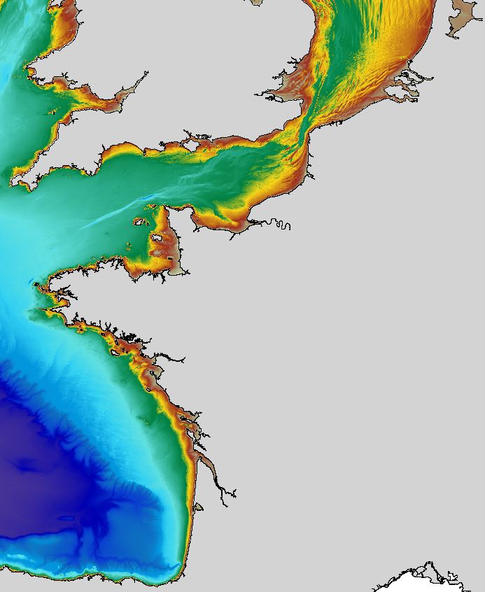
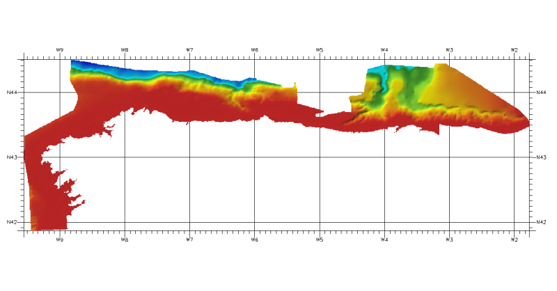
The regional bathymetric Atlantic – Channel – North-Sea DTM has a resolution of 0.001° (~111m). Its geographic coverage includes the Bay of Biscay, the English Channel and a part of the North Sea. The DTM extends from the coast to the continental slope (about of 4800m deep). This DTM is produced in the framework of the HOMONIM project which aims at improving operational forecast capabilities for the national coastal flood warning system. This DTM is offered openly on the Shom diffusion website (http://diffusion.shom.fr/produits/bathymetrie/mnt-facade-atl-homonim.html). http://dx.doi.org/10.17183/MNT_ATL100m_HOMONIM_WGS84
-
Grid processed for the purpose of the HR DTMs layer of EMODnet Bathymetry HRSM, October 2018
-
DTM of coast of Biscay and Guipuzcoa , approximately 250 m resolution. This DTM includes the whole area from coast line to deepest level (144,058 m)
-
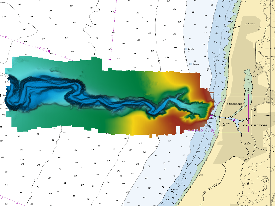
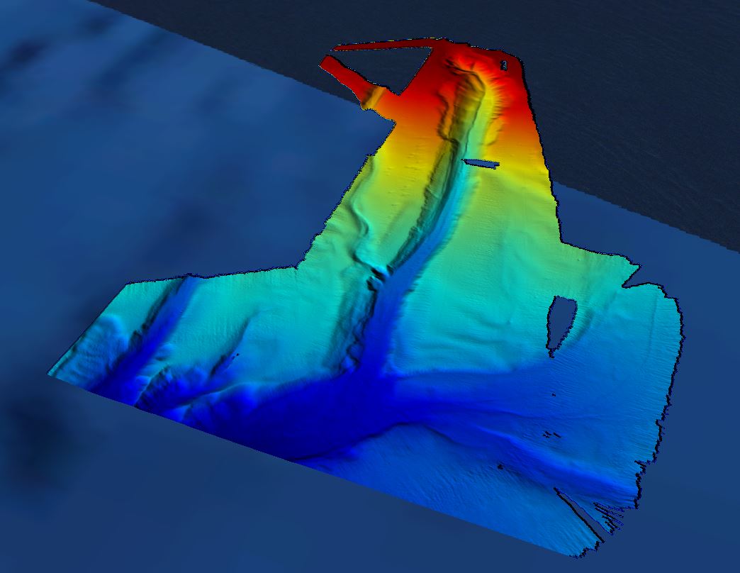
The DTM is a compilation of multibeam echosounder surveys acquired in 2013. The resolution is 1/64 arc-minutes (~30m). Surveys are located on the Capbreton Submarine Canyon (France) with depths from -4.7m to -344.9m. Depths are referenced to the Lowest Astronomical Tide and the coordinates are expressed into the WGS84 reference frame. The surveys which compose the DTM are S201306500-09 and S201306500-11. Data and metadata associated to these surveys are available on the website http://diffusion.shom.fr/pro/lots-bathy.html. The DTM is not to be used for navigation.
-
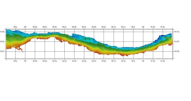
The Digital Terrain Model of the Bay of Biscaye and of the Channel is the result of the processing of a compilation of single and multibeam echosounder data, of DTMs and of chart countours produced before 2008 for hydrodynamic modeling..
-
DTM of continental margin of Cantabric Sea, approximately 200 m resolution. This DTM includes the whole area from coast line to deepest level (5216,74 m).
-
In August 2008, the National Geophysical Data Center (NGDC), an office of the National Oceanic and Atmospheric Administration (NOAA), developed the ETOPO1 Global Relief Model as an improvement to the ETOPO2v2 Global Relief Model. ETOPO1 is available in "Ice Surface" (top of Antarctic and Greenland ice sheets) and "Bedrock" (base of the ice sheets) versions. Both versions of ETOPO1 were generated from diverse global and regional digital data sets, which were shifted to common horizontal and vertical datums, and then evaluated and edited as needed. Bathymetric, topographic, and shoreline data used in ETOPO1 were obtained from NGDC, Antarctic Digital Database (ADD), European Ice Sheet Modeling Initiative (EISMINT), Scientific Committee on Antarctic Research (SCAR), Japan Oceanographic Data Center (JODC), Caspian Environment Programme (CEP), Mediterranean Science Commission (CIESM), National Aeronautics and Space Administration (NASA), National Snow and Ice Data Center (NSIDC), Scripps Institute of Oceanography (SIO), and Leibniz Institute for Baltic Sea Research (LIBSR). ETOPO1 is vertically referenced to sea level, and horizontally referenced to the World Geodetic System of 1984 (WGS 84). Cell size for ETOPO1 is 1 arc-minute.